The Proposals
The Masterplan
The development proposals for the site include the following:
Approximately 61 hectares/ 1.3 million sq.ft. of new logistics development, including a mix of large and small units
A new vehicular access, primarily directing vehicles to the A610 north of the site
A new country park, including enhancement of the River Erewash near the Bennerley Viaduct
Extensive areas of landscaping and biodiversity improvement within the development

Illustrative Masterplan
1.3million
square feet of new logistics development
10%
biodiversity net gain to be delivered on-site
Estimated
1000
Full Time Equivalent jobs (FTE) once the site is operational
River Erewash Country Park
The landscape strategy for the site will look to retain the existing landscape features on site, whilst also creating a variety of different landscape character areas to create a mosaic of landscape types.
These include:
-
Native tree planting
-
Woodland and shrub planting
-
Areas of grassland
-
Wetland planting to complement
River Erewash corridor
_edited.jpg)
_edited.jpg)
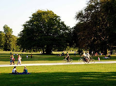


The Country Park is also proposed to include running and walking routes, a ‘trim trail’, and benches throughout the site for park users to enjoy.


Movement Strategy
Access Strategy
The movement strategy for the site has been carefully considered and developed to ensure that it utilises existing junctions and mitigates congestion and traffic where possible. The current strategy includes 3 vehicular access points, as well as anticipated improvements to cycle and pedestrian access to the proposed employment units and country park areas of the site.
Primary Site Access
A fifth arm onto the existing A6096 Shilo Way/ Gin Close Way roundabout. High quality crossings to be provided to connect with existing shared walking/ cycling facilities.
Secondary Site Access
The existing A610 left-in, left-out junction would be retained, providing direct access to the site from the A610.
Third Site Access
A third point of access would be provided to serve both the Country Park and the Small Employment Units, with limited HGV access.

Active Movement
These proposals intend to provide a holistic approach to access and movement for vehicle, cycle and pedestrian traffic. This includes proposals to incorporate enhancements to the strong existing pedestrian and cycle connections, particularly between Giltbrook, Awsworth and Ilkeston.
Pedestrian Connections
The proposals intend to maintain and, where possible, improve walkable connections to the site. This includes practical improvements proposed to the existing footways and crossing points on the A6069 Shilo Way, as well as recreational paths through the proposed country park. This is proposed to include retention of the existing pedestrian connections where feasible, enhanced pedestrian routes, and running/walking routes such as ParkRun.
Cycle Connections
The site is in close proximity to the Erewash Valley Cycle Trail, and offers a strong opportunity to improve the existing cycle connections. With potential to improve cycleways and crossings on the A6069 Shilo Way, as well as connections to recreational routes, this site is well located to support improved active travel connections via bike.


Drainage
The proposals have been carefully designed around the areas of flood risk associated with the River Erewash. All structures are proposed to be located outside of the areas of highest flood risk. A full assessment of the flood risk affecting the site will be undertaken, to ensure that the proposals will not impact or exacerbate offsite flood risk.


Surface water will be managed through Sustainable Drainage Systems (SuDS) principles – ensuring that water is attenuated and drained from the site without affecting the wider area. Attenuation basins will provide drainage benefits to the site, whilst encouraging ecological improvements.


Examples of Sustainable Drainage Systems (SuDS)